New Horizon Drone operates multiple thermal cameras. These thermal cameras serve an array of industries. Below are some common Applications and Use Cases –
- Infrastructure Surveying: collect visual and thermal data in one flight
- Bridge and Structure Inspections: upward camera tilt for structural assessment
- Power Line and Utility Monitoring: thermal and zoom imaging for fault detection
- Public Safety Operations: search and rescue or law enforcement support
- Firefighting: thermal imaging to locate hot spots and monitor fire spread
- Industrial Inspection: detect heat loss, leaks, and equipment defects
- Construction Site Documentation: monitor progress and safety compliance
- Disaster Response: rapid thermal mapping of affected zones
- Environmental and Wildlife Monitoring: detect heat signatures in low visibility
- Maritime and Coastal Missions: operate in wet conditions with IP55 protection
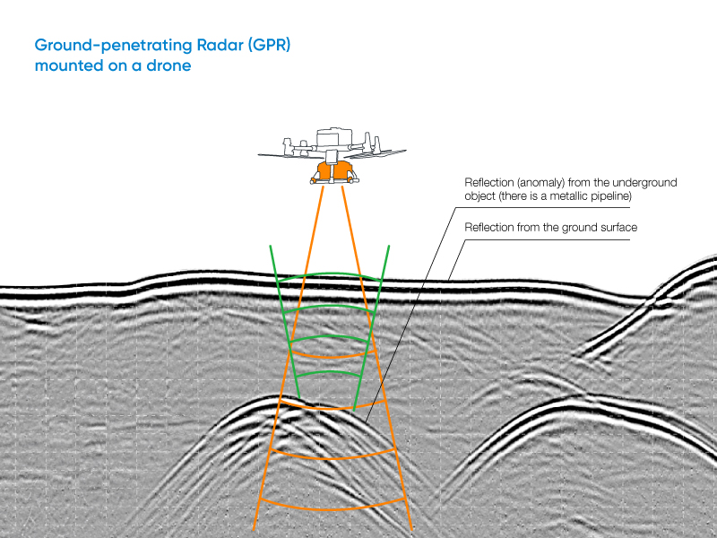
Additionally, NHD also offers a payload featuring Ground Penetrating Radar (GPR). Drone-based GPR enables mapping of glaciers, buried pipelines, and subsurface voids without ground contact. Its low-altitude, terrain-following capability ensures accurate profiles across ice, sand, soil, and shallow water. Integrated with SkyHub and UgCS, UAV GPR surveys maintain a constant altitude for repeatable, centimeter-precise, geo-referenced results.
Field-Proven Applications of Drone-Based GPR Systems


Click here to learn more about these various inspections –
GPR
